Skårhåmmårdalen und Hiortengan

Book Tickets Online

About

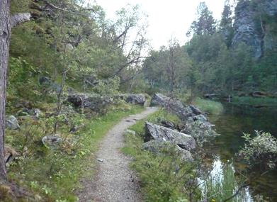
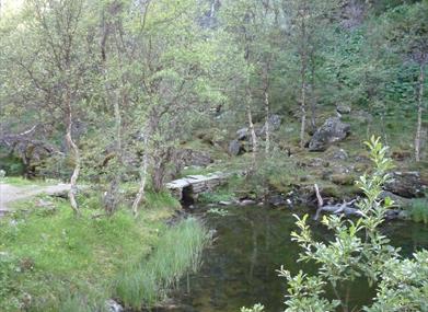
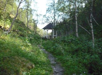
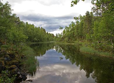
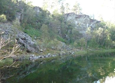
Skårhåmmårdalen is a "canyon" formed during the last Ice Age around 10,000 years ago. The area is located 3 km west of Bergstaden and is easily accessible by bike or car. At the bottom of the canyon lies a picturesque lake. A nice path runs along the lake, leading to the pavilion. The paths and pavilion were established in the last century when Skårhåmmårdalen was a popular recreational area for the well-off residents of Bergstaden. The local climate in Skårhåmmårdalen is favorable, and several heat-loving plants grow here, including redcurrants and herb-paris. 

During the summer, the mining workers moved to mountain farms, while the authorities built garden facilities and pavilions in the countryside. A great bike ride is to the pavilion in Skårhåmmårdalen, or to the garden at Hiortengan - the farm once owned by mining director Peder Hiort.

Facilities

Activities

  • hiking
  • nature trails

Map & Directions

Skårhåmmårdalen und Hiortengan

Type:Adventure

7374, Røros

Add Skårhåmmårdalen und Hiortengan to your Itinerary

Tel: 72410000

What's Nearby

  1. Just north of Røros town centre you will find an area with the distinctive character of a…

    1.2 miles away
  2. The outdoor music threatre Elden is located in the middle of the world heritage in Røros.…

    1.82 miles away
  3. Regional Arts Centre with plenty of events. Regularly hosts performances by the national…

    1.86 miles away
  1. This colorful charming timber town was founded in 1646 and has since developed as both a…

    1.98 miles away
  2. Director Peder Hiort died a rich man. He had no direct descendants. In his will he…

    2.11 miles away
  3. On 8 January 1886 the Fjell-Ljom newspaper published its first issue. Many young writers…

    2.12 miles away
  4. Røros church - also called "The pride of the mining town" - was built in the golden age…

    2.12 miles away
  5. This is a part of town on the opposite side of the Hitterelva river, in relation to the…

    2.16 miles away
  6. Hyttklokka is positioned at the top of Mørkstugata, in proximity to Malmplassen.…

    2.19 miles away
  7. The houses on Sleggveien, Slag road, give some idea of the social history of the mining…

    2.22 miles away
  8. When Røros Copper Works built the first smelter in 1646 people came to get paid work and…

    2.23 miles away
  9. The Smelthytta museum is built on the ruins of the smelter that burnt down in 1975. Here…

    2.24 miles away
  10. Slag is a by-product of copper smelting. Slegghaugan stand as large mountains that are a…

    2.32 miles away
  11. Røros Copper Work's most significant mining area. 12 km from Røros town centre, 1 km from…

    7.32 miles away
  12. Kuråsfossen 1, in Glåmos, was built by Røros Kobberverk and put into operation in 1896.…

    7.72 miles away
  13. Join us for an hour’s walk through 300 years of mining history. The guided tour takes you…

    8.38 miles away
Previous Next

Contact info

Peder Hiorts gate 2

NO-7374 Roros

Norway

Phone: +47 72 41 0000

Email: post@rorosinfo.com

Org.nr. 930 710 652

Roros Tourist Office (+ summer openings)

Monday - Friday: 10:00 - 16:00 (10:00 - 17:00)

Saturday: 10:00 - 14:30 (10:00 - 16:00)

Sunday: Closed (10:00 - 16:00)